|
|
The Map Project is a part of a collection of Arts Resources that has become known as,
Consultation with local Indigenous Authorities
Media Contacts
Media Release Archive
Sponsors
Advertising

Jayne Waterford was interested in starting a publication that reported on art news in the area and invited 26 local operators to meet and discuss the idea. Over two meetings, 18 galleries were represented and other common needs were brought to light. Maps that would enable tourists to walk between galleries became a priority and the publication became an aside.
In the course of mapping land in Australia, it was natural to consult with the local custodians of cultural information that could be featured on our maps. This gave us the added advantage of including exciting and interesting information on our maps that is difficult to come by and worth keeping. Such information guarantees that people using maps have even more motivation to keep galleries' contact details handy.
Art News has since developed other resources valuable to the arts community. They include media contact details, available as individual web-based email links and downloadable PC xls tables of individual writers and journalists. The xls databases and html tables include name, title, postal, physical, fax, email and some particular details of each arts media entity. After publication of the 2001 series of maps this bimonthly updated data will be placed behind a password so as only to be available to participants on the Map Project.
30 000 A3 copies of the Sydney Galleries Map was printed by Serge Martich-Severi Printing and Publishing Pty. Ltd.: Quality Offset (+61 2 9660 5131) in June 2000. It was distrubted in bundles of 300 to participating galleries and museums and to Tourist Information distribution points.
 |
The map was then taken to tonto of smallboy.com who generated the interactive map, the first page developed for this site. |
The entire site is funded from three sources:
- Jan McCulloch of the Art Almanac,
- The galleries who pay for participation and
- sponsors whose logos can be found on the front pages of each state home page. We are particularly grateful to QANTAS who have sponsored us with net cost priced air fares to help us get around and liase with different Aboriginal communities and artists involved with the project.
The Aboriginal component of the Sydney map was the result of collaboration between Allen Madden, from the Sydney Metropolitan Land Council, and Art News. Allen nominated 14 sacred sites that are appropriate for representation on a public map. He also suggested that the clan territories in the Sydney basin, which are traditionally disputed, be represented in such a way that the borderlines are indistinct.


|


 |


 |
 |
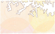
| The original art work supplied by Adam Hill |
The artwork used for future editions of the Sydney Map. |

All artwork for succeeding maps will be displayed on each state or territory home page as it arrives. This year all artwork will be commissioned from indigenous artists considered appropriate by the relevant authorities. Next year we are considering putting the task to a number of young artists to generate the designs for each region.
We are also developing pages for the relevant indigenous authorities who look after the interests of indigenous people in each major urban area. These pages are designed to explain why liaison is often important with these authorities and how the process works in each centre. The variations in protocol are surprising.
This year we are in the process of replicating these services for each primary urban area in each state and territory in Australia. It is our hope that all gallery contact will have been completed by July 15. As soon as completed application forms are received galleries' links will appear in several places on the site and galleries will be able to file information on past, current and future shows on the media release archive.
Physical maps will be printed over the two week period towards the end of June and distributed by mid July. The interactive versions of each map will be developed during August. The costs associated with each production are available on the relevant state or territory home pages on this site.
We are pleased to announce that the Sydney map will be reproduced, along with maps of all other capital centres in states and territories, in June/July 2001. All maps wil be delivered in bundles of 150 by Australia Post by the end of July. Both interactive web-based and download-to-your-own-printer copies of these maps will be available at the end of August. These new maps will feature public transport routes as well as gallery information and map references in easy to use columns on the back in plane black and white.
Several galleries have approached us about advertising on the phycial map. All gallery information will be uniformly presented. The physical map will not carry colour ads for art galleries.
Contact us on +61 2 9977 8411 or email Art News.
Your site up and running...

Australia's Art Publications
and 70 media links

Please go through to
the Interactive Sydney Map 2000

Home Page

2D Art 3D Art 4D Art Aboriginal Art Abstract Art Acrylic Mediums African American Art Animals Animation Animation Cels Antarctica Antiques Antiquities Architecture Art Dealers Art Deco Era in Design Art Guide Art Schools Art Supplies Artefacts Asia Pacific Regional Artwork and Exhibitions Asian Astrology Auction Australian Awards Ballet Bark Beach Beer Biennale Board Body Body Art Bonsai Books Boomerangs Bright Bronze Brut Buddha Buyer Cafe Calligraphy Canvas Cards as Gifts Cartoons Carving as a Technique Celebrity Ceramics Children Chinese Cinema Circus Classic Artworks Classical Cloth Collections Collective Comedy Commissions Community Conceptual Conservation Contemporary Country Couriers Craft Dance Deconstruction Decorative Art Desert Design Didjeridu Digital Distance Documentary Domestic Drawing Dreams Education Emerging Emotions England Entertainment Environment Erotica Established Etchings European Events Experimental Expressionist Exterior Family Fantasy Fashion Female Festival Fibre Art Figurative Film Folk Food Forum Found Object Framing France Functional Fundraiser Furniture Glaciers Glass Gouache Graffiti Greek Group Harbourscapes Haute Couture Heidelberg History Holograms Home Hybrid Identity Illustrations Impressionist Improvisation Indian Indigenous Information Ink Installation Interactive Interiors International Artworks Investment Italian Japanese Jazz Jewelry/Jewellery Korean Land Landscapes Language Lecture Life Life Classes Light Limited Edition Lino Prints Literature Lithographs Love Male Maori Maps Mars Master Medieval Metal Mid Career Mixed Media Modern Monoprints Movies Multi-Media Mural Museum Music NAIDOC Week Native Flora Natural Gothic Na�ve or Naive Art New Guinea New York New Zealand Nude Object Ochre Oil Online Opera Opportunities for Artists Orchestra Outsider Painting Paper Pastel Pastel Painting Performance Persian Photography Place Poetry Political Portraits Post-Expressionist Post-Impressionist Post-Modernism and Post-Modernist Artwork Posters Pottery Primitive Prints Property Publishing Puppetry Purist Radio Ready-Made Realist Regional Religion Rent Residency Restaurant Restoration Retrospective Roman Rural Russian Sale Satellite School Programmes Screenprints Sculpture Seascape Secondary Self Sell Art Sexuality Shop Skin Space Space for hire Sport Still Life Student Artwork Studio studio glass Subconscious Surrealist Symbolist Tapestry Tertiary Text Textiles Theatre Theory Time Time-based Totems Tours of Galleries Traditional Travel Tribal University Urban Valuations Video (workshops, installations and viewing) Vintage Posters Virtual Visions Watercolour Weavings Wetlands Wine Wood as a Medium Workshops